Our Innovation Analysts recently looked into emerging technologies and up-and-coming startups working on commercial drone solutions. As there are a lot of such startups working on various different applications, we decided to share our insights with you. Here, we take a look at 5 promising startups.
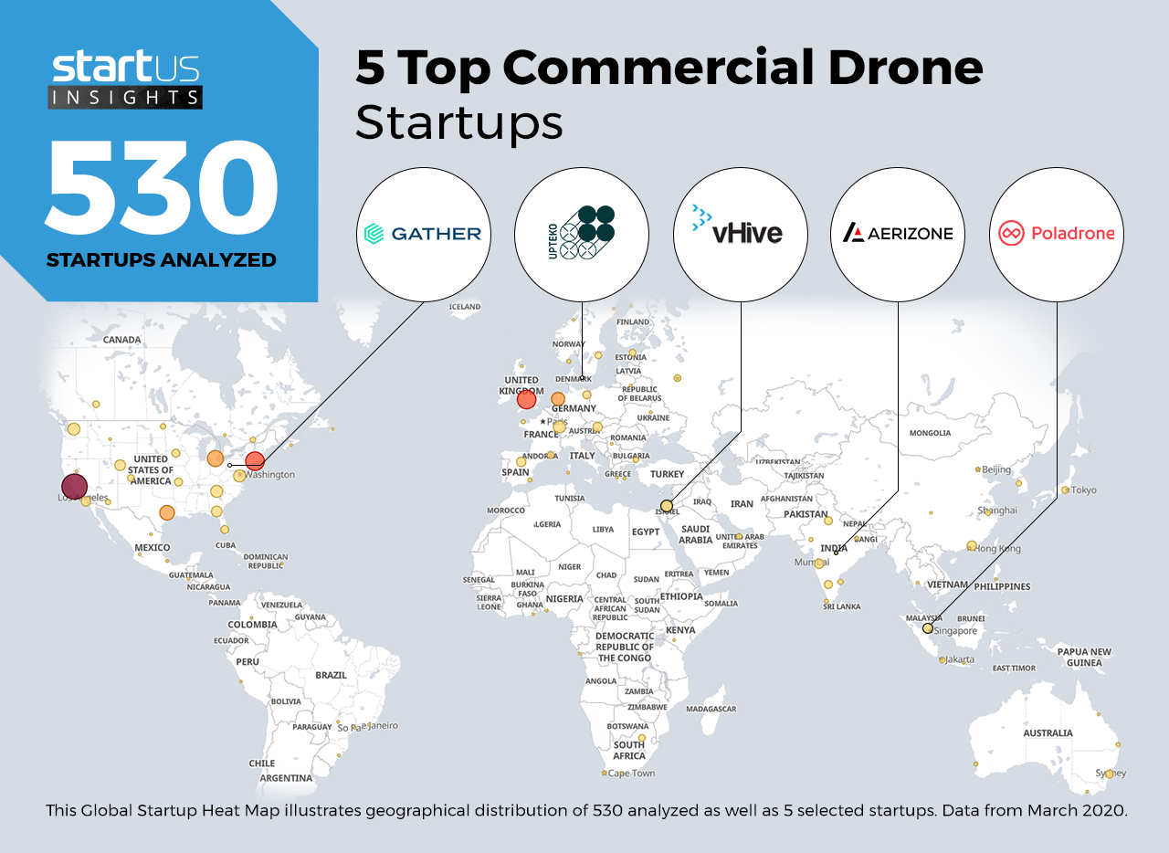
Heat Map: 5 Top Commercial Drone Startups
For our 5 top picks, we used a data-driven startup scouting approach to identify the most relevant solutions globally. The Global Startup Heat Map below highlights 5 interesting examples out of 530 relevant solutions. Depending on your specific needs, your top picks might look entirely different.
Gather – Autonomous Warehouse
Damages in packages are often very subtle, like a slight bulge or tear. These may go unnoticed at multiple checkpoints and cause customer dissatisfaction. Drones equipped with machine vision scan labels, count stock units and check package integrity to minimize such errors and avoid costly recalls.
Gather is a US-based startup that uses a fleet of drones with cameras to map a warehouse environment. The drones can autonomously scan the environment, collect data of the stock, measure temperature, and read barcodes. The startup offers Inventory-as-a-Service and fully automates a warehouse within just a couple of days.
Upteko – Multipurpose Drones
From offshore operations to inland exploration, the demand for data secure and development drones is higher than ever. The protection of critical infrastructure and data is a well-known topic, with endless possibilities for the development of systems.
Upteko is a Denmark-based startup that began by developing drone solutions for the maritime industry but has since expanded into various industries. Through their work with end-to-end solutions and secure drone platforms, they assist companies and others in succeeding with their drone operations. With their open-source drone platform, they contribute to securing the future of new and exciting drone systems.
vHive – Construction Drones
Monitoring large construction projects in real-time is a challenging task. A lapse at any stage in the process contributes to delays and additional costs. Aerial survey solutions that use drones map project sites with great precision and optimize the monitoring process to save costs.
The Israel-based startup vHive develops cloud-based software to deploy drones for construction enterprises. The drones digitally document the site and visualize project areas for better project scoping and resource allocation. This allows site managers to monitor progress, avoid any obstacles and delays, and identify any inaccuracies in the construction.
Aerizone – Drone Geographical Information Systems Mapping
Geographical information systems (GIS) capture, analyze, and present geospatial data to help make meaningful decisions in a large number of industries. Since drones are an affordable way to capture aerial images, they are an attractive data source for GIS. Drones provide near real-time and higher-quality images compared to aircraft.
Aerizone is an Indian startup that uses drones to generate geospatial information to help businesses to make better decisions. They deliver a range of GIS analytics such as total feature extraction, aerial light detection and ranging (LiDAR), slope profile analysis, volumetric analysis, and stockpile management. The startup’s solution applies to multiple industries, including utilities, railways, mining, and forestry.
Poladrone – Crop Spraying
Blanket spraying of crops with insecticides or herbicides poses an environmental and public health risk. It also uses more chemicals than is necessary. Precision crop spraying using drones allows for controlled application and enables precision agriculture.
The Malaysian startup Poladrone offers aerial solutions for the agriculture industry. Their crop-spraying drone, PV16S, has a tank capacity of 16 liters (4.2 gallons) and sprays upwards of 3 hectares per hour. It comes with a professional controller and a fully automated flight app. Polardrone also provides services in crop scouting and aerial surveys for precision agriculture.
What About The Other 525 Solutions?
While we believe data is key to creating insights it can be easy to be overwhelmed by it. Our ambition is to create a comprehensive overview and provide actionable innovation intelligence for your Proof of Concept (PoC), partnership, or investment targets. The 5 commercial drone startups showcased above are promising examples out of 530 we analyzed for this article. To identify the most relevant solutions based on your specific criteria and collaboration strategy, get in touch.


