Staying ahead of the technology curve means strengthening your competitive advantage. That is why we give you data-driven innovation insights into the agriculture sector. This time, you get to discover 5 hand-picked aerial imaging solutions impacting agriculture.
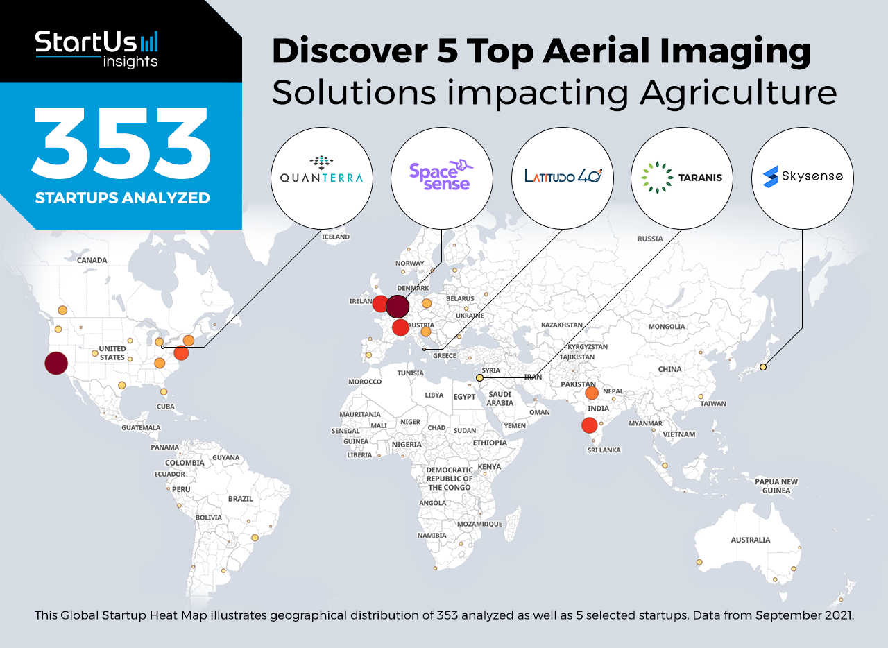
Out of 353, the Global Startup Heat Map highlights 5 Top Aerial Imaging Solutions impacting Agriculture
The insights of this data-driven analysis are derived from the Big Data & Artificial Intelligence-powered StartUs Insights Discovery Platform, covering 2 093 000+ startups & scaleups globally. The platform gives you an exhaustive overview of emerging technologies & relevant startups within a specific field in just a few clicks.
The Global Startup Heat Map below reveals the distribution of the 353 exemplary startups & scaleups we analyzed for this research. Further, it highlights 5 startups that we hand-picked based on criteria such as founding year, location, funding raised, and more. You get to explore the solutions of these 5 startups & scaleups in this report. For insights on the other 348 aerial imaging solutions for agriculture, get in touch.
SpaceSense develops Radar-based Satellite Image Analytics
Farmers depended on agronomic models to simulate and analyze farming conditions which provided only a low degree of accuracy. With the growing pressure on the agricultural industry, farm operators now use aerial imaging to identify farm soil types and their suitability for growing different crops. To this end, startups are leveraging images captured from satellites along with ground data to create highly accurate agricultural monitoring solutions.
SpaceSense is a French startup that develops an artificial intelligence (AI)-powered satellite image analytics solution. Their technology combines satellite imagery with ground sensor data from fields to create analytics models that incorporate crop and local weather data. The startup uses radar-based imaging to avoid the effect of clouds on imaging data, which also captures data at night. This aids farmers to improve operational efficiency, make data-driven decisions, and increase profits.
Latitudo 40 provides an AI-powered Analytics Platform
The increasingly large scale of farms and farming operations require more workforce and technology to efficiently manage them. Big farms rely on automation to solve these challenges but it increases the financial expenses of the entire operation. On the other hand, satellite imaging provides an effective method for farm management. However, farmers find it difficult to access and operate a satellite, which is why startups are creating analytics software that uses images captured from satellites.
Italian startup Latitudo 40 develops an AI-powered analytics platform that utilizes satellite imagery. The platform applies machine learning (ML) algorithms and big data on images from satellite operators’ catalogs and startups in the earth observation landscape. An acquisition engine then finds the best image and cuts out the portion needed for any specific analysis, including weed and plant detection, field health analysis, water stress analysis, and production estimation, among others.
Skysense creates Drone-based Imaging for Farms
Crop diseases are highly transmissible, and, therefore, it is crucial to identify diseased crops as quickly as possible. Large-scale farms are more vulnerable to crop diseases due to the extensive area of cultivation. However, aerial imaging from aircraft or satellites does not provide a sufficient level of detail to identify individual crop conditions. This is why startups are using drones to capture and analyze crop data to prevent diseases.
Skysense is a Japanese startup that provides a drone-based imaging system to prevent damage due to crop diseases and weeds. The startup uses AI on images uploaded from a drone flight to stitch them into an interactive orthophoto map. The interactive map features filters, such as normalized difference vegetation index (NDVI) and visible atmospherically resistant index (VARI), in addition to AI models that count and classify objects. The self-flying drones provide farmers with a cost-effective solution to count plants, scout diseases, monitor plant health, and generate smart maps of farms.
Taranis offers Multi-Level Image Acquisition & Analytics
Satellite imaging provides a good overview of large areas but is poor in fine details. On the other hand, ground-based imaging solutions are beneficial in individual crop analytics but struggle in collecting accurate data over large areas. To provide clarity into granular farm data, startups are analyzing images from multiple sources that offer accurate insights.
Israeli startup Taranis creates an agronomy software platform that uses data from multiple sources. This includes data from skilled operators, proprietary logistics, satellites, planes, and drones. The library of leaf-level ground images is digitized by agronomists using machine learning and computer vision to generate insights. The software combines the benefits of different imaging sources and facilitates engagement between agronomic advisors, farm owners, and growers.
Quanterra enables Aerial Inspection Automation
The agricultural industry utilizes drones, satellites, and aircraft to collect images to drive agronomy insights. Although aerial imaging provides many benefits, the main challenge remains the effective analysis of recorded images. Typically, analytics software requires specialized knowledge or dedicated agronomic scientists to generate basic reports. This is why startups are creating solutions to automate the task of generating reports from drone image data.
Quanterra is a US-based startup that builds software to analyze image data from drones. The startup’s CattleQuants service uses an AI engine to count cattle using aerial images of feedlots and pastures. Once the images are captured by drones, the AI engine begins to automatically process the data and generate detailed reports. The solution, thereby, allows farm owners and operators to reduce in-person inspections, verify inventory, and accurately inspect feed yards and pastures on a monthly basis.
Discover more AgriTech Startups
AgriTech startups such as the examples highlighted in this report focus on remote sensing, geospatial intelligence, and informatics. While all of these technologies play a major role in advancing the agricultural industry, they only represent the tip of the iceberg. To explore more agricultural technologies, simply get in touch to let us look into your areas of interest. For a more general overview, you can download our free AgriTech Innovation Report to save your time and improve strategic decision-making.